Plains Plateaus and MountainsStudents the earth as you know is very beautiful. Lakes, rivers, mountains, vast plains, canyons, plateaus, forests and many other "land forms" and natural features of the land all comprise a majestic view of the earth.In this lesson we are going to learn about three of the main forms of land: Plains, Plateaus and Moutains. 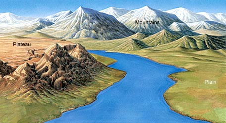
PlainsPlains are large, flat areas, often found in the interior regions of continents. The flat land of plains is ideal for agriculture. Plains often have thick, fertile soils and abundant, grassy meadows suitable for grazing animals. Plains also are home to a variety of wildlife, including foxes, ground squirrels, and snakes. When plains are found near the ocean, they're called coastal plains. Together, interior plains and coastal plains make up half of all the land in the United States.
Costal Plains
|


 |
The Atlantic Coastal Plain, began forming about 70 million years ago as sediment began accumulating on the ocean floor. Sea level eventually dropped, and the seafloor was exposed. As a result, the coastal plain was born. The size of the coastal plain varies over time. That's because sea level rises and falls. During the last ice age, the coastal plain was larger than it is now because so much of Earth's water was contained in glaciers. |
NEED costal plain photos here.
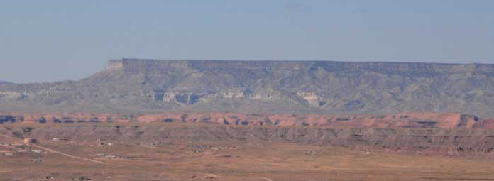
Plateaus
At somewhat higher elevations, you will find plateaus. Plateaus are flat, raised areas of land made up of nearly horizontal rocks that have been uplifted by forces within Earth. They are different from plains in that their edges rise steeply from the land around them. Because of this uplifting, it is common for plateaus, such as the Colorado Plateau, to be cut through by deep river valleys and canyons. The Colorado River, as shown in Figure 3, has cut deeply into the rock layers of the plateau, forming the Grand Canyon. Because the Colorado Plateau is located mostly in what is now a dry region, only a few rivers have developed on its surface. If you hiked around on this plateau, you would encounter a high, rugged environment.
 |
Plains and plateaus are fairly flat, but plateaus have higher elevation. A in the picture is short-grass prairie in Kansas which is part of the Great Pains. The Great plains are interior plains. Picture B shows how the Colorado river carved the Grand Canyon into the Colorado Plateau. |
Black Mesa Plateau in Arizona
 |
 |
This is a picture of the Andes Mountains in Chile. Can you see the plateau hidden in the backgroud? |
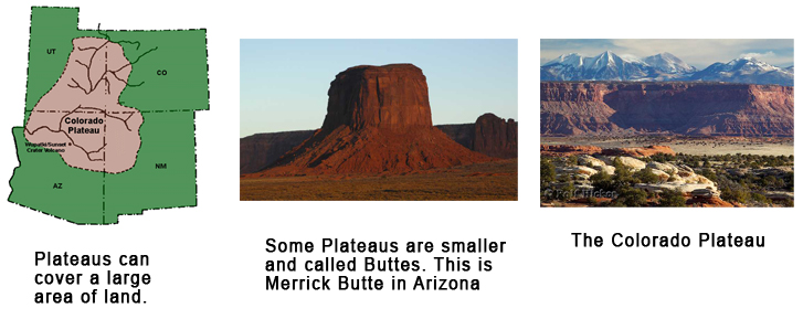
A plateau is much larger than a mesa. A mesa may have been a plateau
once but through erosion is now smaller in size. A butte is sometimes thought
to be a flat hill but a butte might be a mesa that through erosion is now a
smaller butte.
Mountains
Mountains are majestic towering forms of rock that rise high into the sky. Mountains with snowcapped peaks often are shrouded in clouds and tower high above the surrounding land. If you climb them, the views are spectacular. The world's highest mountain peak is Mount Everest in the Himalaya more than 29,000 ft. (8,800 m) above sea level. By contrast, the highest mountain peaks in the United States reach just over 18,00 ft. (6,000 m). Mountains also vary in how they are formed.Mountain Building
Mountains form because of the movement of the very large sections of the crust moving in different directions with great force. The largest sections of the earth's crust are called PLATES. But even large plates of crust will have regional areas in them where the crust folds in on itself, or breaks and shifts, or rises high into the sky. This shifting and thrusts of the crust forms mountains.
There about 5 main ways for the earth's crust to form mountains:
Folding, Fault-block, upwarp, dome and volcanic.
Folded Mountains
Folded mountains form when the crust is pushing in on itself from opposite directionsforcing the crust to fold upward, just like a rug on your living room floor being push in from two sides the middle of the rug will wrinkle-up in folds.
 |
These are the Banff Mountains in Canada. They formed when the crust was folded upward by forces pushing on other side toward each other creating a fold in the crust. |
 |
Sometimes when stress is applied to the rocks of the crust, the rocks bend but do not break. The rocks bend in much the same way a rug wrinkles as it is pushed across a floor. A bend in a rock is called a fold. As you can see, a rock can fold either upward or downward. An upward fold in a rock is called an anticline (AN-tih-klighn). A downward fold in a rock is called a syncline (SIHN-klighn). |
Fault-Block Mountains
There are large Cracks or Faults in the earth's crust. At time these cracks allow for a large block of crust to rise up and tilt creating a Fault-Block mountain. |
Fault block mountains are made of huge, tilted blocks of rock that are separated from surrounding rock by faults. These faults are large fractures in rock along which mostly vertical movement has occurred. The Grand Tetons of Wyoming, shown here, and the Sierra Nevada in California are examples of fault-block mountains. When these mountains formed, one block was tilted and pushed up, while the adjacent block dropped down. This mountain-building process produces majestic peaks and steep slopes. |
Upwarped Mountain
Upwarped mountains form when blocks of Earth's crust are pushed up by forces inside Earth. Over time, the soil and sedimentary rocks at the top of Earth's crust erode, exposing the hard, crystalline rock underneath. As these rocks erode, they form the peaks and ridges.
 |
The Adirondack Mountains in New York, the southern Rocky Mountains in Colorado and New Mexico, and the Black Hills in South Dakota are upwarped mountains. Here you see a mountain range in Colorado. Notice the high peaks and sharp ridges that are common to upwarped mountains. |
Dome Mountains
A dome mountain forms when a large chamber of magma rises close to the surface of the earth and pushes the crust up.Volcanic Mountains
Volcanic mountains form when the lava spewed out of the volcano solidifies and becomes rock. Over many volcanic eruptions the lava builds up a mountain.We will go into greater depth of volcanic mountains in another chapter.
 |
Volcanic Mountain |
 |
Dome Mountain |
Watch Videos on Landforms and Mountain Building